The next step is to identify engineering and construction phasing and investigate what funding mechanisms might be available to implement this project.
- Home
- At a Glance
-
-
About Us
-
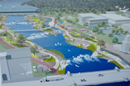 The goal of the St. Charles Active River Project is to create a lively riverfront environment and experience that is the centerpiece of the community.
-
-
- Purpose
- News & Events
- VIDEOS
- Contact Us
FAQ
for Government Services CommitteeFAQ's for Government Services Committee
of the St. Charles City Council
Prepared by the Active River Task Force
Now that the engineering study is complete, what is the next step?
The city of St. Charles would inform the US Army Corp of Engineers that they do not want the dam removed until funding is available to implement the Active River. At which point the city will take ownership of the current dam, and the IDNR will provide 60% of the funding to remove the current dam at the appropriate time.
The concept designs were utilized as the basis for the cost estimates. While these designs reflect a buildable design based on the detailed study of the riverbed, water flows, etc. any final design may be substantially different. The actual design needs to reflect community input, regulatory requirements, sponsorship commitments, environmental issues, and input from similar projects across the country.
In general, the basic concept designs call for returning the river to its natural, narrow condition within the project limits. This will provide potential for cycle and walking pathways underneath both sides of the Main Street bridge as well as increasing the space available for pathways on the east side of the river under the railroad trestle to better accommodate pedestrians and cycles in a safe manner. Low flow conditions are expected to mimic the conditions that currently occur downstream of the dam.
The concept designs accommodate 100 year flood conditions as indicated on those graphics. In fact, the project is expected to provide some flood plain benefit within the project limits including a reduction of floodplain inundation of Rt. 31. Any design will also assume that certain features, such as walking paths, may be flooded on occasion - just as we now have on the path under the Prairie Street bridge along the west side of the river.
The project will be designed specifically for safe passage by canoes and kayaks. The passage from upstream to downstream will be possible without portage. The passage from downstream to upstream will require a short portage, which will be facilitated with easy access to and from the river on wide access trails.
A primary objective of the project is to improve public safety on the river. The concept plan would enhance safety with the tiered cascade layout and the dam-like control mechanism design(s) would minimize the water “boil”. The proposed project will significantly improve public safety within the project limits.
This is yet to be determined and is subject to discussions among the City, the St. Charles Park District and the Illinois Department of Natural Resources. We have identified specialized consulting firms that have helped many other successful projects define and organize the ownership and maintenance issues. This will include on-going funding mechanisms for both operational and capital requirements.
See above. The City currently provides this service as required on the existing St. Charles dam.
In this portion of the project there are four private land owners. If the project proceeds with the next steps, the design team will need to work closely with those landowners along the west bank to ensure that their concerns and needs are addressed. We intend to provide those landowners with improved access to the downtown and enhanced business opportunities.
The section of the project defined for this engineering study is the key to many other components because of the potential for providing improved access under the Main Street bridge and in developing additional recreational opportunities that are the basis for improved economic development within the downtown district. The Park District has already begun planning for changes to the boat launch, parking and boat slips on Boy Scout Island; and have begun conceptualizing alternative routes for an improved bike trail along the east side of the river. Project components south of the Main Street bridge can be designed and constructed in future years as funding sources and needs are defined. It is envisioned that once this key section is designed and constructed that a number of opportunities will be presented for consideration. Each of these proposals will be evaluated as they are presented relative to an approved final design complete with community and agency input.
The engineering feasibility study utilized a detailed river bottom survey conducted by the Corps of Engineers within the past few years. Included in this were detailed measurements of the actual silt depth in the river. The actual silt build-up behind the existing dam is minimal based on the data from this study. A majority of the existing sediment is located along the east and west banks of the river and will need to be carefully managed during construction in accordance with regulatory requirements.
No, but we believe that there is potential to provide dock facilities to provide boaters with improved access to river trail networks and easy access to downtown businesses.
Copyright ©2020 St. Charles Active River Project. All rights reserved.